
an introduction
Remote sensing, in the context of geospatial technology, refers to the process of acquiring information about the Earth’s surface without direct physical contact. It involves using sensors, such as satellites or aircraft, to capture data from a distance.
These sensors measure various types of electromagnetic radiation reflected or emitted by the Earth’s surface. The collected data can then be analyzed to obtain valuable insights about the environment, such as land cover, vegetation health, or atmospheric conditions.
Remote sensing plays a crucial role in monitoring and understanding our planet, aiding in applications like mapping, environmental assessment, agriculture, and disaster management.
a brief history of remote sensing
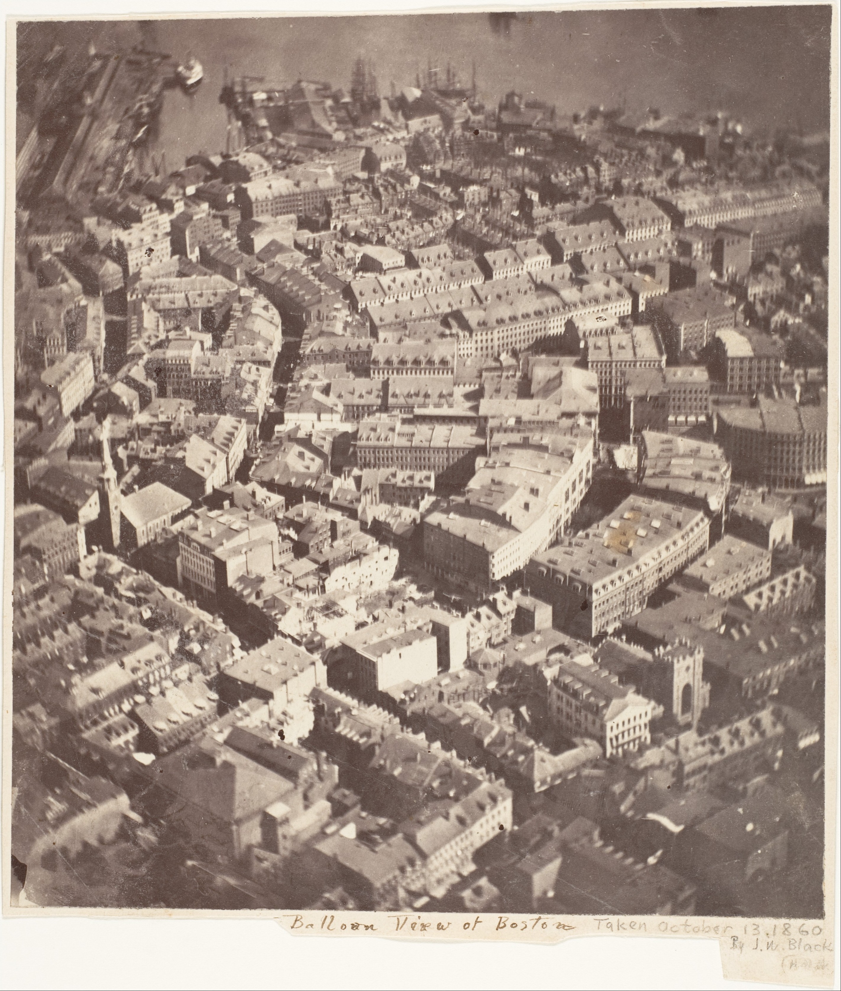
1840s: The first aerial photograph is captured by James Wallace Black from a hot air balloon over Boston, marking the beginning of aerial imaging.
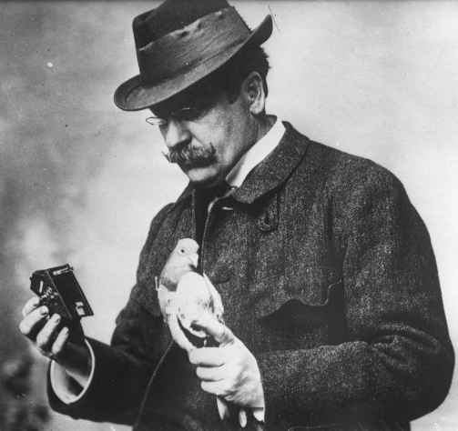
1903: Julius Neubronner invents a pigeon camera that captures aerial photographs.
1920s: The development of photogrammetry techniques leads to advancements in aerial mapping and surveying.
1940s: World War II sees significant progress in aerial reconnaissance and the use of aerial photography for military purposes.

1957: The launch of the Soviet satellite Sputnik 1 marks the beginning of the space age and the use of satellites for remote sensing.

1960s: The United States launches the first Earth observation satellite, TIROS-1, for weather monitoring.

1972: The Landsat program is initiated, providing a continuous record of Earth’s surface through a series of satellite missions.

1980s: Digital imaging technology begins to replace traditional film-based imagery, making image analysis and processing more efficient.
1990s: Advancements in sensor technology lead to the launch of high-resolution satellites such as IKONOS, enabling detailed mapping and analysis.
2000s: The launch of the Moderate Resolution Imaging Spectroradiometer (MODIS) provides global coverage and facilitates monitoring of Earth’s land, ocean, and atmospheric conditions.

2010s: Rapid development of unmanned aerial vehicles (UAVs) or drones opens up new opportunities for close-range aerial imagery and data collection.
Present: Remote sensing continues to evolve with the launch of advanced satellite missions, including high-resolution optical and synthetic aperture radar (SAR) sensors. Integration with GIS, machine learning, and big data analytics further enhances the analysis and interpretation of remote sensing data.

what types are there?
- Optical Remote Sensing: This type involves capturing data in the visible, near-infrared, and thermal infrared regions of the electromagnetic spectrum. It uses sensors that detect reflected sunlight to gather information about land cover, vegetation health, and surface temperature.
- Multispectral Remote Sensing: Multispectral sensors capture data across multiple specific wavelength bands. This allows for the identification and analysis of different surface features based on their spectral characteristics. It is widely used in applications such as vegetation monitoring, urban planning, and geological mapping.
- Hyperspectral Remote Sensing: Hyperspectral sensors capture data in many narrow and contiguous bands across the electromagnetic spectrum. This enables detailed analysis of the spectral signatures of materials, leading to improved identification and classification of surface features. It is used in various fields, including agriculture, mineral exploration, and environmental monitoring.
- Synthetic Aperture Radar (SAR): SAR sensors use microwave pulses to measure the backscattered signals from the Earth’s surface. It provides valuable information about topography, land cover, and surface roughness. SAR is particularly useful for applications like monitoring changes in land deformation, detecting forest structure, and mapping coastal areas.
- LiDAR (Light Detection and Ranging): LiDAR sensors emit laser pulses and measure the time it takes for the pulses to return after interacting with objects on the Earth’s surface. This data is used to create highly accurate 3D models of terrain, vegetation, and man-made structures. LiDAR is widely used in mapping, forestry, urban planning, and flood modeling.
use cases
Remote sensing data can be used for many different purposes. Here are some example use cases:
- Environmental Monitoring: Remote sensing techniques such as satellite imagery and aerial photography are used to monitor and assess changes in land cover, vegetation health, and natural resources. It helps in detecting deforestation, monitoring water quality, assessing air pollution, and tracking the impact of climate change on ecosystems.
- Agriculture and Crop Monitoring: Remote sensing data, including multispectral and hyperspectral imagery, is utilized for crop health assessment, yield estimation, and precision agriculture. It helps farmers optimize irrigation, fertilisation, and pest control measures based on the spatial variability of crops.
- Urban Planning and Development: Remote sensing data, including orthophotos and LiDAR (Light Detection and Ranging) data, aids in urban planning by providing information on land use, infrastructure, and population dynamics. It helps analyse urban growth patterns, identify suitable locations for infrastructure development, and assess the impact of urbanisation on the environment.
- Disaster Management: Remote sensing techniques, including synthetic aperture radar (SAR) and thermal imaging, play a crucial role in disaster management, including early warning systems, emergency response, and post-disaster assessment. It provides real-time data on wildfires, floods, hurricanes, and earthquakes to support decision-making and aid relief efforts.
- Natural Resource Management: Remote sensing data, such as LiDAR and radar imagery, helps in the sustainable management of natural resources such as forests, water bodies, and minerals. It aids in mapping and monitoring these resources, assessing their health and biodiversity, and guiding conservation efforts.
- Archaeology and Cultural Heritage: Remote sensing techniques like LiDAR and aerial photography are used for archaeological surveys, site mapping, and the identification of hidden or buried structures. It helps uncover ancient civilisations, map cultural heritage sites, and preserve historical landmarks.
- Climate Change Studies: Remote sensing data from satellites, including microwave sensors and altimeters, provides valuable information for studying climate change. It helps monitor ice cover, sea level rise, and carbon emissions, enabling researchers to understand and predict the impact of climate change on ecosystems and human societies.
Remote sensing terminology
- Electromagnetic Spectrum: The range of wavelengths of electromagnetic radiation, including visible light, infrared, and microwave, which are detected by remote sensing sensors.
- Pixel: The smallest unit of a digital image or raster data, representing a single value or measurement at a specific location on the Earth’s surface.
- Spatial Resolution: The level of detail captured by a remote sensing sensor, determined by the size of the pixel and the ground area it represents.
- Spectral Resolution: The number and width of the spectral bands or channels in a remote sensing image, indicating the range and sensitivity of wavelengths captured.
- Radiometric Resolution: The sensitivity of a remote sensing sensor to detect and record variations in energy or reflectance values, often measured in bits.
- Orthorectification: The process of geometrically correcting an image to remove distortions caused by terrain relief, sensor perspective, and Earth curvature.
- Multispectral Imagery: Remote sensing data captured in several discrete spectral bands, usually in the visible and infrared regions, allowing analysis of specific features or properties.
- Hyperspectral Imagery: Remote sensing data captured in many narrow and contiguous spectral bands, providing detailed information about the chemical and physical properties of objects.
- LiDAR (Light Detection and Ranging): A remote sensing technique that measures the distance between a sensor and the Earth’s surface using laser pulses, allowing the creation of highly accurate elevation models and 3D point clouds.
- Synthetic Aperture Radar (SAR): A remote sensing technology that uses microwave signals to generate high-resolution images, allowing day-and-night and all-weather observations.
- Image Classification: The process of categorizing pixels or image regions into different classes based on their spectral properties, enabling the identification of land cover types or features.
- NDVI (Normalized Difference Vegetation Index): A vegetation index derived from remote sensing data, indicating the health and density of vegetation based on the difference in reflectance between the red and near-infrared spectral bands.
common band combinations
Landsat 8:
- Natural Color: Band 4 (Red), Band 3 (Green), Band 2 (Blue)
- False Color (Vegetation): Band 5 (Near-Infrared), Band 4 (Red), Band 3 (Green)
- Urban Area: Band 7 (Shortwave Infrared 2), Band 6 (Shortwave Infrared 1), Band 4 (Red)
- Healthy Vegetation: Band 5 (Near-Infrared), Band 6 (Shortwave Infrared 1), Band 2 (Blue)
Landsat 7:
- False Color Infrared: Band 4 (Near-Infrared), Band 3 (Red), Band 2 (Green)
- Healthy Vegetation: Band 4 (Near-Infrared), Band 3 (Red), Band 1 (Blue)
- Agriculture Analysis: Band 5 (Mid-Infrared), Band 4 (Near-Infrared), Band 3 (Red)
- Burned Area Detection: Band 7 (Mid-Infrared), Band 4 (Near-Infrared), Band 1 (Blue)
Landsat 5:
- Natural Color: Band 3 (Red), Band 2 (Green), Band 1 (Blue)
- False Color Infrared: Band 4 (Near-Infrared), Band 3 (Red), Band 1 (Blue)
- Vegetation Analysis: Band 4 (Near-Infrared), Band 3 (Red), Band 1 (Blue)
- Urban Area: Band 7 (Mid-Infrared), Band 4 (Near-Infrared), Band 3 (Red)
Sentinel-3:
- True Color: Band 7 (Near-Infrared), Band 6 (Red), Band 3 (Green)
- Vegetation Index: Band 7 (Near-Infrared), Band 6 (Red), Band 1 (Blue)
- Chlorophyll-a Index: Band 8 (Red), Band 6 (Red), Band 2 (Blue)
- Land/Water Mask: Band 8 (Near-Infrared), Band 6 (Red), Band 2 (Blue)
Sentinel-2:
- Natural Color: Band 4 (Red), Band 3 (Green), Band 2 (Blue)
- False Color (Vegetation): Band 8 (Near-Infrared), Band 4 (Red), Band 3 (Green)
- Land/Water Boundary: Band 8 (Near-Infrared), Band 11 (Shortwave Infrared 2), Band 2 (Blue)
- Coastal/Aerosol: Band 1 (Coastal), Band 4 (Red), Band 3 (Green)
Sentinel-1 (SAR):
- Single Look Complex (SLC): HH (Horizontal Transmit, Horizontal Receive)
- Co-polarization: HH or VV
- Cross-polarization: HV or VH
MODIS:
- True Color: Band 1 (Red), Band 4 (Green), Band 3 (Blue)
- Vegetation Analysis: Band 2 (Near-Infrared), Band 1 (Red), Band 4 (Blue)
- Snow/Ice Detection: Band 6 (Shortwave Infrared), Band 1 (Red), Band 2 (Near-Infrared)
remote sensing resources
- Earth Explorer: Earth Explorer is a data portal provided by the United States Geological Survey (USGS). It offers access to a wide range of remote sensing datasets, including satellite imagery from missions such as Landsat and Sentinel. Website: https://earthexplorer.usgs.gov/
- Copernicus Open Access Hub: The Copernicus Open Access Hub, operated by the European Space Agency (ESA), provides access to the data from the Sentinel missions. It offers a vast collection of remote sensing data for various applications. Website: https://scihub.copernicus.eu/
- NASA Earth Observing System Data and Information System (EOSDIS): EOSDIS provides access to NASA’s Earth observation data, including satellite imagery and remote sensing datasets. Their website offers various data access tools and resources. Website: https://earthdata.nasa.gov/
- United States Geological Survey (USGS): The USGS provides access to remote sensing data, including satellite imagery and elevation data. Their website offers data portals and tools for searching and downloading data. Website: https://www.usgs.gov/
- European Space Agency (ESA): ESA’s website provides access to remote sensing data from their Sentinel missions, as well as other Earth observation missions. It offers a range of resources, including data access tools and documentation. Website: https://www.esa.int/
- Earth Observing System Data Gateway (EOSDIS): EOSDIS, operated by NASA, provides access to a vast collection of Earth observation data, including remote sensing datasets. The website offers data discovery and access tools for exploring and downloading data. Website: https://earthdata.nasa.gov/eosdis/daacs
further reading
- Earth Observing System Data and Information System (EOSDIS): The EOSDIS is a comprehensive resource provided by NASA, offering access to a wide range of remote sensing data from various Earth-observing satellites. Website: https://earthdata.nasa.gov/
- United States Geological Survey (USGS): The USGS provides access to satellite imagery and remote sensing data, including data from Landsat missions. Website: https://www.usgs.gov/
- European Space Agency (ESA): ESA offers remote sensing data from their Sentinel missions, providing a wealth of information for various applications. Website: https://www.esa.int/
- National Oceanic and Atmospheric Administration (NOAA): NOAA provides access to a variety of remote sensing data, including weather satellites and oceanic observations. Website: https://www.noaa.gov/
- Remote Sensing Tutorial by NASA: This online tutorial by NASA provides an introduction to remote sensing, covering the basic principles and applications. Website: https://earthobservatory.nasa.gov/learn/remote-sensing
- Remote Sensing and Image Interpretation by Thomas M. Lillesand, Ralph W. Kiefer, and Jonathan Chipman: This book is a widely used resource for learning about remote sensing principles and techniques. It covers a range of topics from data acquisition to image analysis. Book link: https://www.wiley.com/en-us/Remote+Sensing+and+Image+Interpretation%2C+7th+Edition-p-9781118343289
- Remote Sensing of the Environment: An Earth Resource Perspective by John R. Jensen: This book provides a comprehensive overview of remote sensing applications and techniques, covering both theoretical foundations and practical examples. Book link: https://www.pearson.com/us/higher-education/program/Jensen-Remote-Sensing-of-the-Environment-An-Earth-Resource-Perspective-2nd-Edition/PGM179607.html
- IEEE Geoscience and Remote Sensing Society (GRSS): The GRSS is a professional society dedicated to advancing remote sensing technology and applications. Their website offers access to journals, conferences, and resources related to remote sensing. Website: https://www.grss-ieee.org/
summary
Remote sensing is a powerful technology that allows us to gather information about Earth’s surface without direct physical contact. It involves capturing and analyzing data from airborne or satellite sensors, providing valuable insights into various aspects of our planet.
By detecting and measuring the electromagnetic radiation reflected or emitted by different objects, remote sensing enables us to study land cover, monitor environmental changes, assess crop health, map urban areas, and much more.
It plays a vital role in fields like environmental science, agriculture, forestry, and disaster management. With advancements in technology and the availability of satellite imagery and other data sources, remote sensing has become increasingly accessible, making it an essential tool for understanding and managing our planet.


Leave a comment